

Geographic Map of Latin America Physical Map of Latin America
Latin America is among the world's largest culture regions, with the greatest latitudinal ranging from 32 degrees north latitude to 56 degrees south latitude. It has a total area of 20.5 million square kilometers, and a total of 34 nations within the continent. The range in altitudes within the region resulted in its highly diversified ecology and many of its outstanding physical characteristics.
Latin America is divided into five regions by altitudinal zonation. The peak region is called Tierra Neveda, this region is above the snow line (around 15000 ft in altitude). There are no economical produces within this region, due to its climate. The region below the snow line is called Tierra Helada, at a height above 12000ft. Some trees grow in this area. However, due to its cold nature, not many crops are grown in this area. The next region is Tierra Fria, this region is from 6000 to 12000 ft. Crops that are presented in this region are potatoes, corn and coca. The following region is Tierra templada, ranging from 3000 to 6000 ft. This is also the most populated region in Latin America. Farming are common in this region, including coffee, corn and wheat. The last region is the Tierra Caliente, sitting on an altitude of 3000ft and below. This region is full of tropical fruits and tropical agricultures.The graphs below show the altitudinal zonation of Latin America and the agricultural produces from each region.


Latin America is divided into 13 natural regions based on their
physiographic characteristics. The regions, however, have similar
characteristics in climate, natural vegetation, and soils.The following map shows the 13 different regions.

Gulf-Caribbean Coastal Lowlands

The Yucatan peninsula,lies south of Mexico, is a platform of coral rock with limestone beds, and is characterized by shallow, dry rendzina soil with many sinkholes and few surface streams. In pre-Columbian times, the peninsula was the cultural hearth of the Mayan civilization.
The Atrato and Magdalena valleys of Colombia and the Maracaibo basin of Venezuela also lies in the coastal lowlands containing Latin American's largest lakes. These areas attract migration from the highlands because of its tropical crops in Colombia and petroleum production in Venezuela.
Antilles


The total area of Antilles is 238,000 square kilometers, which Cuba alone occupying one-half of the total area. The rest are made up mostly from the Greater Antilles, Hispaniola, Jamaica, and Puerto Rico. The island is enclosed by the Caribbean sea, as a result it is exposed to hurricanes. The climate of the region is tropical, but plantation agricultural economy has declined in the recently years, and the major economic activities has shifted toward tourism and commerce. The Antilles also forms one of the world's most important archipelagoes.
Pacific Littoral: Coastal Plains and Valleys

 Buenaventura Port
The Pacific Littoral represents the pacific margins of Middle America and the northern section of South America. This region consist of diverse physical landscapes. The peninsula of Baja California, in Mexico, represent the southern extension of the Pacific mountain system of North America. Across the Gulf of California lies the Sonoran desert, the southward extension of the basin and range topography of the United States. Many of the river valleys of southern Sonora and northern Sinaloa are densely settled due to irrigation projects from the rivers. The growing commerical importance of the port of Buenaventura has stimulated population migration in to the Pacific coastal margins of Colombia. The coastal margins and Guayas lowlands of Ecuador is densely populated due to its agricultural productions, especially bananas, and the convenient transportation system of the the ports in Guayaquil.
Coordilleran Ranges: Intermontane Basins and Plateu

The Coordilleran Ranges is the most extensive natural region in Latin America. The area of the region is more than 12,000 kilometers. It is also one of the most populous region with about 170 million inhabitants.

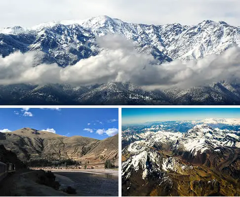
Aconcague Mountain
Climate and vegetation vary in accordance with altitude and temperature in the Coordileran area. The more productive basins have numerous urban communities and rural concentration.
Orinoco Llanos
 |
| The Orinoco River |

The Llanos lie between the Venezuelan-Colombian Andes and the Guiana highlands. This region is drained by the Orinoco River system. This basin is the third largest in Latin America, accommodating the third greatest river,the Orinoco River, discharge in the region. The Orinoco River flows through a diverse landscape of dry forests, grasslands, and seasonally flooded plains before it disperses into a river delta of swamp forests and coastal mangroves as it approaches the Atlantic.This region also consist of some of the world's richest tropical grasslands, harbouring more than 100 species of mammals and over 700 species of birds.
Guiana Highlands

 |
| The plateaus of the Guiana Highlands |
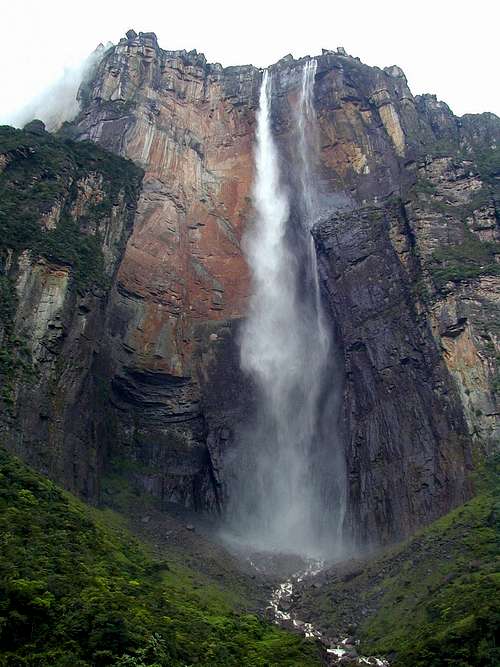 |
| Angel Falls (Highest waterfall on Earth) |
The Guiana highlands is about 60 percent larger than the Llanos. Much of the upland surface has been dissected by streams. Guiana highlands also has the world's highest waterfalls, located near the Venezuelan-Guyanan border. Populations are sparsely settled in this region.
Amazonia


 |
| The Amazon River |


The Amazon basin is the largest natural region and one of the most homogeneous in Latin America. Despite of it's large area, only 3 percent of the population resides here. The Amazon River is the greatest river on earth in volume, and second longest river following the Nile river. The Amazon accounts for nearly 1/5 of the total world river discharge into the oceans. It is also the most navigable river system on earth. There is no bridges across the Amazon in its entire lowland traverse of the continent. There is also a massive amount of diversity among the species of wild lives that inhabit there.
Brazilian Highlands


The Brazilian highlands are an extensive geographical region associated with 1/3 of the Latin American population. The main geographical feature of the area consist of tropical rain forest, or monsoon, and it is surrounded by broad leaf evergreen forests. The southern highland section has a humid subtropical climate, and on the Parana plateau, soil hospitable to coffee.
Peruvian Atacama Desert


 |
| Atacama Desert |
The Peruvian-Atacama desert region is a narrow coastal zone that stretches across a area of 3000 to 3500 kilometres, from near the Ecuadoran-Peruvian border to Coquimbo, Chile. This coastal zone is perhaps the driest strip of land on Earth, due to a combination of the Pacific anticyclone, the cool Humboldt current and the winds that parallel the coast. Arica, Chile, has the lowest average annual precipitation on earth. There is great mineral wealth in Chile, including nitrates and copper. There are also abundant iron ore in Peru. However, only 1/10 of the national population resides here.
Middle and South
Chile


 |
| Andean glaciers |
 |
| Middle Chile |
The middle and south Chile region is completely different from northern Chile. This region is comprised mostly with agricultural land and it is also full of mineral wealth. In middle Chile, precipitation is greater and is continuous during the year. Southern Chile is the most important forest producing region and also the site of major mineral production of copper. In the peak south region in Chile, the Andean glaciers reach sea level. This is one of the four major fjorded coasts on earth. The region is rugged and isolated, it is also cold, rainy and dreary.
Patagonia


The Patagonia and northwest Argentina compose one of the larger of the natural regions of Latin American, however, still lying entirely within Argentina.Most of the settlement and irrigated agriculture occur in the basin oases of the foothills. The soils of Patagonia and part of Tierra del Fuego are desert soils, productive when irrigated, and are suitable for the cultivation of fruits especially. There are some mining communities in northwest Argentina. Petroleum is produced in both coastal Patagonia and the Andean foothills of the northwest. Much of the region, however, is sparsely settled and devoted to livestock ranching.
Plata- Parana Basin

The Plata-Parana basin encompasses the La Plata estuary, the master stream Parana, and its tributaries, notably the Paraguay and Uruguay rivers. The basin lies mostly within northeastern Argentina and is one of the most populous of the natural regions. The soil from the area are mollisols, deep and dark with organic matter and minerals. These are the richest soils in latin America and among the best in the world. Soil qualities deteriorates toward the drier Northwest and Patagonia, as we move into the humid tropics. The prevailing climate over most of the region is humid subtropical, rainy summers and mild winters.
=====================================================================
The Andes
The Andes is the longest and highest continental mountain range in the world. The range stretches across the western coast of Latin America for a length of about 7000 km. The average height of the mountain range is about 4000 m in altitude, with the highest peak, Mt. Aconcague, at an elevation of about 6962m above sea level. The Andes also consist of near maximum for most of the world's features (except summits), for instance, highest settlements, highest capital city, highest snowline, and highest volcanos.

No comments:
Post a Comment